
Measuring tapes measure short distances, levels measure, well, level, and watches measure time.
What do GPS rovers measure? Coordinates.
GPS measures coordinates, then our data collector uses the coordinates to let us measure all kinds of things on our site. Lengths, widths, distances, basically whatever needs to be measured. Because it’s based on our site coordinates, and our site map on the data collector is as well, we can easily get an accurate relationship to everything on our site.
The basic coordinates that our GPS measures are x,y, and z. For this Rundown we won’t get too much into the z, or elevations. We’ll just focus on 2D horizontal measurements for now. Everyone has played the game Battleship before, right? Below is a basic “battleship” grid, and it was likely our first introduction to how coordinates work.
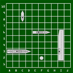
Let’s get our imagination rolling here and pretend that this is a construction site. The location of our rover is the white dot. On this coordinate grid, the numbers on the left hand side represent our “x” coordinate. The letters across the bottom represent our “y” coordinate. Using coordinates to determine your location only works accurately if you have both an x and a y coordinate. If I said my rover is at “2” there are 10 possible locations it could be. So we narrow it down by giving it a “y” coordinate as well. By saying my rover is at “2,F” we can pin point on the grid where the rover is.
The above battleship grid is very basic. We could relate this grid to real life by assuming each square is 5m x 5m. Our site grid though, as it relates to GPS, would have squares 1mm x 1mm. Which allows us to locate ourselves on the site very accurately. This is the basis of GPS positioning as it relates to our site.
I’m not going to get into coordinate systems in this Rundown, because that’s a big subject. But you need the basic understanding of coordinates to understand how GPS measures things on our site. The next piece of the puzzle is our data collector software. It’s the link between our GPS coordinates and numbers that we can understand.
To turn GPS coordinates into a linear measurement, the software knows our site grid, and all the linework in our site map is assigned grid coordinates. So let’s say we’re staking our edge of pavement line, and we get a value of 1.2m left of EP. The software is taking the coordinates of our GPS rover and the coordinates of the EP line at that specific point along the line, and calculating the distance between them. Doing this in real time, every time we slightly move the rover. It’s pretty amazing stuff.
Just to touch on elevations, this same relationship with coordinates takes place with the 3D model. The software recognizes the 3D model in the same site coordinates, and assigns an elevation to each coordinate. So using the 3D model to check your grade, for instance, the software is adding an elevation to the site coordinate and compares it to our current position and elevation, and you magically get a cut value if your elevation is higher than the design elevation.

Leave a comment